Sunday, May 31, 2015

Road Trip to Bandon

When we came to the Oregon coast in 2009 we stopped one day and had what seemed to be the best fish and chips we've ever eaten at a little shack on the Bandon wharf.  Even though Bandon is just over 100 miles from where we are staying, we felt it was worth the drive to go back and see if our memories were being honest with us.

Heceta Head Light
We headed south on the coast highway past Cape Perpetua and through the 11.5 foot tall tunnel, then stopped at the top of the next hill to take a couple of pictures.  Last summer I told you about the Nubble Light at Cape Neddick, Maine, which was felt to be the epitome of all light houses and was included on the data disk sent into deep space with the Voyager probe.  But for my money, Heceta Head Light is even more iconic as light houses go.  It sits halfway up a mountain, jutting out high above the ocean to flash out a light signal visible for God knows how many miles.  Our viewpoint was a pullout on the highway just below Sea Lion Cave, across a small inlet from from the Hecita Head Light.  Nubble is nice, but I think Heceta is at least as much the embodiment of what a lighthouse is all about.

Restored Coquille Light
We continued south past the Suislaw National Forest and drove through Reedsport where we had hit the coast on Hwy 38 a few days earlier, then continued south into new territory.  We passed through North Bend and Coos Bay, then just before Bandon we pulled off at Bullards Beach State Park where we visited the Coquille River Light.  No one is going to award any prizes to this small lighthouse which sits across the Coquille River from Bandon but it is picturesque enough.  It was the last US Coastguard lighthouse built along the Oregon coast and operated from 1896 to 1939.  A fire largely destroyed Bandon in 1936 and with the subsequent lack of significant shipping in the area the light was shut down as unnecessary.  It was replaced some years later by a small automated light placed on the jetty on the Bandon side of the river.  The Coquille River Light was allowed to fall into ruin until a local restoration project picked it up in 1976.  It is now an interpretive center staffed by RV work
Replacement light on the south jetty
campers who are given free parking for their rigs at the Bullards Beach campground in exchange for spending a few hours a week answering tourist questions inside the lighthouse.  I assume they get some kind of training, but maybe they just make the answers up.  We certainly wouldn't know the difference.

The Bandon Fish Market and Chowder House
Finally we went back to Hwy 101, crossed the Coquille River Bridge and entered Bandon.  A large sign welcomes you to the Old Town area where the Bandon wharf is located and we parked just about 50 yds from the Bandon Fish Market where the Fish and Chips are produced.  For fifty years this place has made cod and halibut fried fish and chips.  There are a few other things on the menu.  They've added salmon fish and chips since we were last here and had some fresh tuna that particular day.  They've also added the option of having your fish grilled instead of deep fried, but that's not what we had driven 100 miles for.  I had a cup of clam chowder and Vicki ordered a cup of
Perfect fish and chips (and so-so coleslaw)
smoked salmon chowder, and we each had an order of cod fish and chips.  It was pretty much as we remembered it.  The batter was light and crispy and the fish was moist and so soft it almost melted in your mouth.  I don't know how they do that.  I mean, if it were simple, everybody's fish would taste like this.  I had thought that the secret was that the fish were fresh off the boat, caught the same day, but on asking I learned that this particular cod had come from Alaska.  So I don't know what their secret is, but I may have to drive the 100 miles again to consider the question further before we leave the state.

Across the street from the Fish Market sits the Cranberry Sweets and More store where they make fruit fudges and pates (apparently a fancy way of saying jelly candies).  These are delicious, if somewhat expensive (they averaged about $22 or $23 a pound) .  We each got a few of ounces things that looked good to us along with two chocolate dipped cherries and moved on.
Sunset Bay State Park (with my phone panorama)
Cape Arago
On the way back north we stopped at a number of state parks and waysides.  In particular, we drove the Cape Arago Highway which hugs the coast over a section where 101 does not.  This took us to Sunset Bay State Park, which is a beautiful little round inlet with a large sand beach protected by high cliffs around about 3/4 of its circumference.  This is a favorite spot for locals and tourists alike and gets over 1.5 million visitors a year.  A few miles further along is Cape Arago where Francis Drake is supposed to have sheltered the Golden Hind from storms in 1579 while he was searching for the western end of the fabled Northwest Passage.

Watching the show at the Elquarium
When we got to Reedsport, we turned right and drove a few miles back out Hwy 38 to visit the Dean Creek elk viewing area or, as I like to call it, the Oregon Coast Elkquarium.  This is a 1080 acre preserve with a herd of about 100 Roosevelt Elk that stay in the area all year.  They're wild (sort of) but the area is fertilized and maintained to provide plenty of food so they don't need to  migrate away to forage.  Next to the highway is a  large marshy grassland where they can be viewed from a raised gazebo platform with handicapped accessibility.  May and June are calving season and the pregnant females all head up into the mountains for some privacy, so what we saw was a small herd of mostly males feeding leisurely about a hundred yards from the viewing platform.  They all had fuzzy little antlers which will grow throughout the summer to become 6 foot wide racks by September when they start banging their heads together over the women.  Thus it has always been.

While we were watching the Elk, this rather bedraggled Blue Heron flew into the marsh to do a little fishing.  We've seen a few of these over the years in various shades of blue.  This guy looks pretty grey to me.
Greyish Blue Heron
We finally arrived back at our motorhome at about a quarter past eight to discover that our rig was running on battery power.  The 50 amp circuit breaker at our electric post had quit working.  I knocked on the manager's door and told him about it and after a brief inspection he agreed that the circuit breaker had not "tripped", it had failed and would need to be replaced.  He offered to do it that night, but we had a 30 amp converter cord and with the motorhome plugged into the 30 amp breaker it seemed to work fine, so we left it like that overnight and he came over and replaced the 50 amp breaker the next morning.  I don't know when the next morning exactly.  I certainly didn't get out of bed to watch.

Bonus Pics


Heceta Head with the lighthouse halfway up the mountain on the left and the keepers house on the right


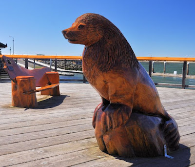
Wood carvings on the Bandon wharf.


Formation flying


View from Shore Acres State Park
Sunset Bay


Fuzzy antlers

Group of mostly males


Friday, May 29, 2015

Coming to the Coast

From Sutherlin we headed out on the 138 again, this time in the Monaco with our car trailing behind us.  When we got to Elkton, we took Hwy 38 west and in a little over an hour found our selves on the Oregon coast where we are scheduled to spend a month enjoying the spectacular scenery, abundant seafood and cool summer weather.  When we reached the coast highway, we turned north, grousing about how our GPS seemed to be malfunctioning. When we left Sutherlin for some reason it wanted us to take US 20 from I-5 instead of OR 38.  We figured it was dealers choice and the GPS would figure it out eventually, but it consistently refused to recalculate the route even though we were by now only a few miles from our campground.  We sailed past the Oregon Dunes and through Florence, ignored the Sea Lions Cave for the moment and rolled down the hill to find this...

The GPS, which knows how tall our motorhome is, was not malfunctioning, it was trying to tell us our 12.5 foot rig was about to meet an 11.5 foot tunnel and wanted us to go back the way we came.  Of course it didn't come out and say "There is a low tunnel on your route", nooo... it just told us to go 200 miles out of our way for no very well spelled out reason.  We were disconcerted momentarily until we noticed that the 11.5 foot figure only applied if you hugged the tunnel wall as you went through.  In the center the height was over 16 feet.  We probably could have stayed in our own lane, but there was no one coming toward us, so we just lined ourselves up on the double yellow line and sailed through with no problem.  Suddenly the GPS told us we were only 20 miles from our destination rather than the 238 miles it had previously been insisting on.

Special exhibit
Our first couple of days on the coast were pretty grey and dismal, so we opted for some indoor activities, such as the Oregon Coast Aquarium in Newport.  This was actually our third visit to the aquarium.  The first time was when our son was little.  The second was 6 years ago after we had shipped him off to college and were traveling on our own again for the first time in many years.  So we had seen it all before, but it's still a fun place to visit.

They had a special exhibit that was not suppose to open until the following day, but I guess they figured it was finished and ready to go so they went ahead and opened the doors a day early.  It was ostensibly about shipwrecks but was really more of a  primer on underwater archeology.  It was mildly interesting but clearly geared for a younger crowd. 
Unauthorized snack

We meandered through and looked at the fishies and jellies.  This guy looks like he snuck himself an unauthorized snack.  One problem with the aquarium is that all your photos are taken through 2 inch thick plexiglass which plays havoc with your camera's autofocus and even if you focus manually, the stuff isn't very clean.  At least at the hands-on tidepool exhibit, you're looking directly at the water.

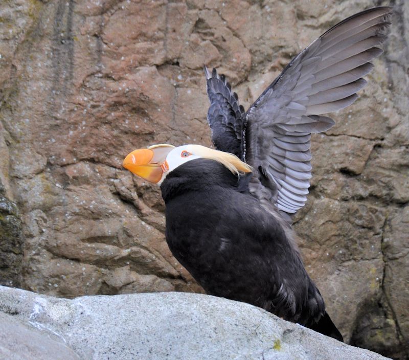
Outside they have a seabird aviary.  They had a
Tide pool area
few atlantic puffins and guillimots like we saw last summer in Maine (story here), but they also had tufted puffins which are more of a west coast phenomenon and, as such, are much more fashion obsessed.  There are also outdoor enclosures for seals, sea lions and otters, but they have the same plexiglass problem the fishes have.
Tufted puffins giving me the eye
When we got out of the aquarium the harbor had misted up a little, making for some interesting photos.  Be that as it may, we are hoping for some better weather as the month progresses.

Bonus Pics


Newport marina
Yaquina Bay Bridge

Another puffin

Sea otter through plexiglass

Lion fish

Seals from our 2009 visit (when it was sunny).

Monday, May 25, 2015

CXXXVIII

Oregon Hwy 138 is a scenic highway that primarily follows the course of the Umpqua River.  It runs from Diamond Lake in the Cascades, to the small town of Elkton, where Hwy. 38 can take you the rest of the way to the Oregon coast.  It joins the I-5 briefly at Sutherlin where we were staying for a week which made it easy for us to explore. 

The Rochester covered bridge
A couple of miles west of Sutherlin a short detour from Hw 138 proper will bring you to the Rochester covered bridge which crosses over the Calapooya Creek.  This 80 foot long bridge was built in 1933 and is still in daily use by the locals in the area.  Covering the bridges kept the sun and rain off the support beams and can tripel or quadruple the life of a wooden bridge.  Because of the endless rain here, covering the bridges was pretty standard and at one time there were more than 300 covered bridges in the state.  As wood has been replaced by concrete as the bridge building material of choice, that number has dwindled to about fifty.  Covering a concrete bridge is expensive and unnecessary.

In the late 1950s when urban renewal fervor hit the US, some of the powers that been in Douglas County felt that it was time to replace all the old wooden bridges with new concrete models.  Another covered span nearby got mysteriously torched one night and the locals around Sutherlin were afraid the Rochester Bridge might be the next on the list, so the community got out their hunting rifles and stood guard over the bridge at night.  The county commisioners decided modernization wasn't worth an armed stand-off and took the Rochester Bridge off the replacement list which is why we have it to admire today.  By 1969, preservation was more fashionable and the bridge got remodeled at county expense, replacing weather worn structural components to make it safe for another generation.

The Umpqua River
Beyond the bridge, Hwy 138 meanders through the hills.  We took it all the way to Elkton before we turned back.  Whenever I leave Southern California, it takes me a while to get use to how wet and green other places can be.  The road goes through a mixture of forests and farm/ranch lands that to my desert weary eyes were as beautiful as anywhere you could want to go.

The Winchester Dam with the fish ladder on the left.
At Sutherlin the 138 joins the I-5 for a few miles going south to Roseburg.  Along this short stretch it passes the Winchester Dam. This structure was built in 1890 and was originally only 4 feet high and made out of wood.  This was replaced by a 16 foot concrete dam in 1907.  The dam created a fresh water reservoir for Roseburg and was used to generate hydroelectric power until 1923.  Now it's not used for anything as far as I could find out, but it has been designated as a national historic site, so they can't just dynamite the thing. 

Ziva develops an interest in fish
In order for fish to reach their spawning grounds a fish ladder was installed at the north end of the dam.  By descending a nearly infinite number of stairs you can visit the ladder and view desperately horny salmon and steelhead trout through a couple of large plexiglass windows.  They also video the fish so some poor technician can count them and make notes about ID tags and predator scars and whatever else the fish and game biologists want to know.  I enjoyed viewing the fish for a few minutes, but being a professional fish counter sounds like possibly the most boring job on the planet.  I would think that after a month you would start talking to the fish.  After 6 months, they would start talking back.

Colliding Rivers
At Roseburg our highway leaves the I-5 going through the middle of old town  and heads toward the Cascade Mountains.  About 12 miles east a sign marks the turn off for the Colliding Rivers Visitor Center.  Here the Little River and the North Umpqua River meet head on before the now merged North Umpqua continues on toward the sea.  When there is a lot of water flowing it is apparently an impressive site but the day we were there it was pretty calm.  It is a little hard to make out from the photo but the view is from the top of the T with the North Umpqua to the left and the Little River coming in from the right.  If I had thought about it I would have taken a video instead.  I have trouble remembering all of the capabilities of my smart phone.

Lunch alone
We stopped at a roadside park to eat our picnic lunch.  It was right on the river, beautiful with grassy areas and about 9 or 10 nice picnic tables  And we were THE ONLY ONES THERE.  It's astonishing to me that places this nice get ignored, even if it is before memorial day.  Folks up here don't know how good they have it.

Hwy 138 runs on the north side of the North Umpqua River.  Immediately on the other side of the river is the North Umpqua Trail, a 79 mile trail for hiking, mountain biking and horseback riding.  Every 8 or 10 miles there is either a car or foot bridge across the river
Tioga Bridge
to provide access to the trail.  We stopped at one such, the Tioga Bridge, which was completed in 2012.  Formerly at this spot sat the Youngs Bay Bridge, but it was washed out during a flood in 1964. Given that the bridge sits about 100 ft above the current level of the river, that must have been some flood. The new bridge sits on the concrete piers left from the old one.  Interestingly, the wooden bridge was built along the side of Hwy 138, then lifted with a giant crane and set down on the concrete piers.  We crossed the span so we could say we saw the North Umpqua Trail.  We did not hike the 8 miles to the next foot bridge, though I think the dogs were up for it.

Rarin' to go.
There are supposedly a number of nice waterfalls within reasonable walking distance of the road a bit further up the mountain and our intention was to visit a couple of them, but as we moved deeper into the Cascades the sky got progressively darker and then started to produce some serious rain.  Did we let that stop us?  You bet we did.  We tucked our tails between our legs and hightailed it back to Sutherlin.  We were due to move out for the coast the next day, so waterfalls will have to wait for another visit.