Greetings from Munising, Michigan. We're staying in this little town on the southern shore of Lake Superior which bills itself as "the Upper Peninsula's best kept secret". I'm not sure how secret it is- we managed to find it without any difficulty.
 |
| Eagle Harbor lighthouse on the Keweenaw Peninsula |
After leaving Sturgeon Bay we spent a few days in Hancock, Michigan on the Keweenaw Peninsula which were uneventful. It is a nice area but seemed like a case of déjà vu having just left the Door Peninsula in Wisconsin. On the way to Hancock, a friendly passing truck kicked up a rock and put a ding in our windshield, so we had to invest a half day getting that fixed (rather than wait and risk having to replace the windshield somewhere down the road for a grand or two). More of the joy of life on the road. We were also treated to another severe thunderstorm watch in Hancock but other than some gusty winds, nothing came of it. Most of the serious action passed south of us.
 |
| Sunset from our Munising campground |
Both in Hancock and here in Munising we are staying in campgrounds owned and operated by the cities in order to bring in the tourists. These are surprisingly nice camping facilities in surprisingly nice places. Both campgrounds are right on Lake Superior and have spacious, grassy campsites. The only drawback is the lack of sewer hookups, but for a stay of only two or three days at a time, we can live with that. Our current campground has its own sandy beach about 100 yards from our front door. The sun heats up the water near the shoreline so that it is reasonably swimmable and we have taken advantage of this. It is cold getting in, but certainly no colder than the Pacific Ocean at Newport or Huntington Beaches. But on a sunny summer day in California you compete with thousands of people for beach space. Here, we were practically by ourselves.
 |
| Pictured Rocks National Lakeshore |
Munising's primary claim to fame is its proximity to Pictured Rocks National Lakeshore, 114 square miles of scenic land and shoreline between Munising and Grand Marais, Michigan (not to be confused with Grand Marais, Minnesota which we discussed previously). Exactly what the difference is between a National Park and a National Lakeshore was not entirely made clear to me. Most of the land that is currently part of the National Lakeshore was confiscated by Alger County for nonpayment of property taxes after the lumber ran out in about 1910. While they considered this highly valuable real estate for tax purposes, in real life they realized that without trees it had no economic value and was a burden around their necks, so the county council worked out a deal with the federal government and it became federal land. The land part of the lakeshore contains half a dozen viewable waterfalls, streams, small lakes and what is currently considered scenic forest land (now that it has had a century to recover). But by far the most attractive part is the coastline, which is hard to see if you're standing on top of it, so it is best toured by boat.
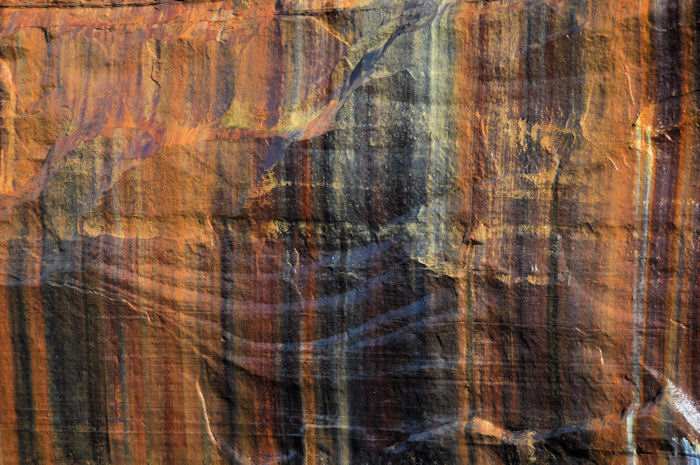
Fourteen miles of the coastline consists of sandstone cliffs rising up to 200 feet above the water line. Most of the sandstone is the Munising Formation which is about 500 million years old and soft, but

the top layer, the Au Train formation, is younger and, most importantly, harder and forms a protective cap over the softer rock below. The erosive action of the lake cuts back into the softer stone until an overhang gets too heavy and a section will come crashing down. This keeps the cliff faces nearly vertical. Groundwater seeps down through the sandstone carrying minerals with it and some of this seeps out through the cliff faces where the water evaporates, leaving behind mineral deposits. This creates colored streaks on the rock that people think makes them look painted. The colors depend on which minerals predominate in a given area, iron (red), manganese (black-white), limonite (yellow-brown) or copper (pink-green). Close to the water line the wave action of the lake, particularly during winter storms, gouges out numerous small and a few large sea caves and some natural arches. Overall, this creates a shoreline of breathtaking beauty.
 |
| Obviously not us |
The best way to see it is in a kayak, but you know we're not paddling 40 miles anytime soon. You can rent a small pontoon boat for about $400 a day and have a nice survey of the coast on your own schedule or, for $36, you can take a tour boat and see the sites on their schedule, which is what we opted for since you will recall that we have no actual income. The tour boat was about 60 feet long with open-air seats on top and an enclosed area underneath. By the time we got on the boat the top level was full, so we ended up stuck inside. The weather was beautiful and the water was pretty smooth, good picture taking conditions. You just had to figure out a way to get near an open window when you needed to, which was somewhat frustrating but doable. The ride lasted about three hours and covered essentially the same territory going and coming, so if you missed something on the way out you had another chance at it on the way back.
 |
| About 60 feet long with two observation levels. |
There was only one sad aspect to the tour. We ran into our old friend, Bridal Veil Falls. You will recall that we first saw this waterfall back in May at Yosemite National Park where it was a mighty cascade over sheer drop into the canyon. We next ran into it along the Columbia River Gorge in Oregon where it had apparently
recently moved and gotten broken into two sections in the process. This
never really healed right and the waterfall was let go from its job in
Oregon and took employment in a small park in the Black Hills of South
Dakota where we saw it again in July.

Look at it now, barely a trickle coming down the cliff side here in Michigan. Oh how the mighty have fallen. We could barely stand looking at it from embarrassment. Hopefully Bridal Veil Falls will now quietly retire and avoid further deterioration.
 |
| Bridal Veil Falls |
Overall, we really enjoyed the tour. If you're ever in this area you should absolutely not miss seeing the National Lakeshore one way or another. We thought if we ever came back we might invest the extra bucks and rent a boat but there is no telling when that might be.
Bonus Pictured Rocks pictures:
 |
| Miners Castle |
 |
| What most of the trip looked like from my seat |
 |
| Paint stripes |
 |
| Numerous small caves near the water line |
 |
| Lovers Leap Arch going out |
 |
| Lovers Leap Arch coming back |
 |
| Rainbow Cave |
 |
| The Ojibwa saw the face of The Great Spirit in this cliff face |
 |
| Battleship Row |
 |
| Flower Vase |
 |
| Chapel Rock |
 |
| Spray Falls |
 |
| Happy Tourist |
 |
| Tour boat by the partially restored East Bay Lighthouse |


 the top layer, the Au Train formation, is younger and, most importantly, harder and forms a protective cap over the softer rock below. The erosive action of the lake cuts back into the softer stone until an overhang gets too heavy and a section will come crashing down. This keeps the cliff faces nearly vertical. Groundwater seeps down through the sandstone carrying minerals with it and some of this seeps out through the cliff faces where the water evaporates, leaving behind mineral deposits. This creates colored streaks on the rock that people think makes them look painted. The colors depend on which minerals predominate in a given area, iron (red), manganese (black-white), limonite (yellow-brown) or copper (pink-green). Close to the water line the wave action of the lake, particularly during winter storms, gouges out numerous small and a few large sea caves and some natural arches. Overall, this creates a shoreline of breathtaking beauty.


No comments:
Post a Comment